

The weak cold boundary sliding across the state overnight will bring noticeable changes to Thursday’s forecast, delivering a brief interruption to the dominant heat dome. The relief, however, will be far from uniform across Oklahoma in terms of both cloud cover, temperature drops, and actual precipitation.
Temperatures: Stepping Down from the Century Mark
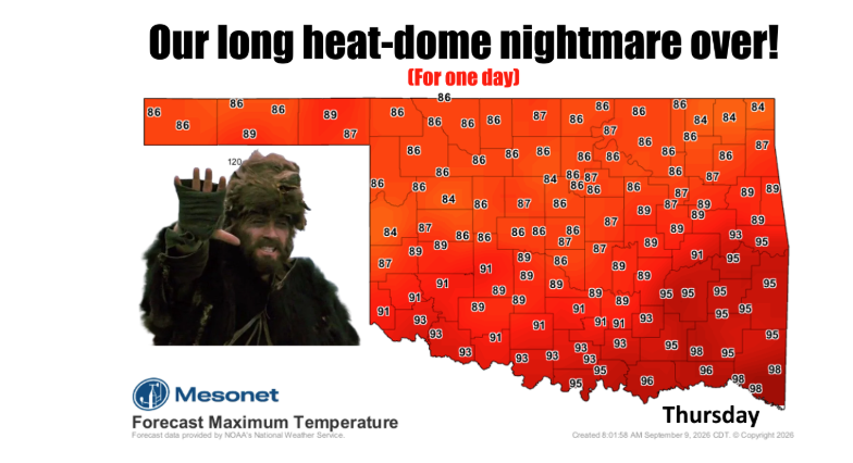
After enduring triple-digit highs across much of the state, Thursday will offer the coolest afternoon seen in days, especially where cloud cover and scattered showers hold firm:
- Northern & Northeastern Oklahoma: Highs will see the sharpest drop, generally staying in the low to mid-80s thanks to heavy cloud decks, higher humidity, and morning-to-afternoon shower activity.
- Central Oklahoma: Highs will hover in the upper 80s to lower 90s—a distinct drop from the century mark, though elevated humidity will temper how cool it feels outside.
- Southern & Southwestern Oklahoma: The front will lose momentum as it pushes south, meaning areas along the Red River and into the southwest corner may still push into the mid-90s, seeing only a modest shave off the recent extreme heat.
Rainfall: A Tale of Two Halves
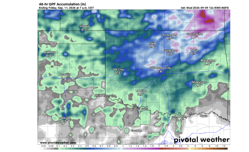
Precipitation chances highlight the familiar northeast-versus-southwest divide that often plagues late-summer fronts:
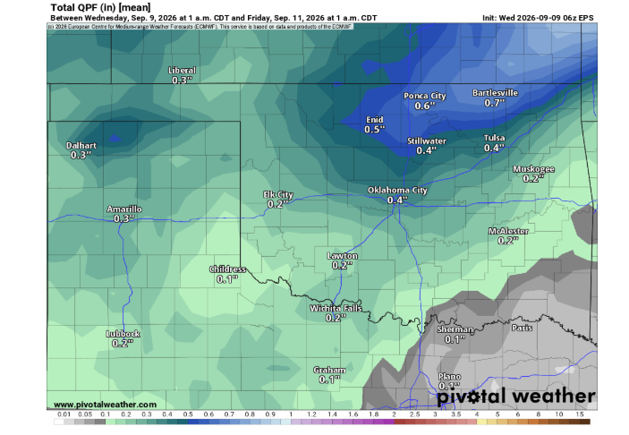
- The Bullseye (Northeast): Numerical models and ensemble guidance place the highest probability of measurable, soaking rain across northeast and east-central Oklahoma. Expected accumulations could range from a half-inch to over an inch in pockets, giving parched pastures and lawns a much-needed drink.
- The Deficit (Southwest): Moisture diminishes dramatically toward southwest Oklahoma. Forecast models indicate little to no measurable rainfall for far southwestern counties, leaving them largely on the dry side of the boundary.
Soil Physics at Work: Sensible vs. Latent Heat
The moisture that does fall will do double duty on Thursday. Bone-dry soil directly converts solar radiation into sensible heat—the heat you feel radiating off bare ground that directly cooks the air temperature higher. When rain wets the ground, that same solar energy is diverted into latent heat through evaporation. Even where rain amounts are modest, the added soil moisture helps cool the local microclimate until the sun bakes it away.
The Clock Is Ticking
Thursday’s respite will be fleeting. As the boundary washes out and winds veer back around to the south, the heat dome will rapidly reassert control, pushing high temperatures back toward the upper 90s and triple digits across most of the state by Friday afternoon.
To read more from State Climatologist Gary McManus on his mesonet ticker, click here: