
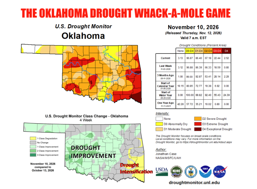
While steady rainfall over the past month has chipped away at drought conditions across much of western and central Oklahoma, eastern Oklahoma remains locked in a stubborn dry pattern, according to State Climatologist Gary McManus.
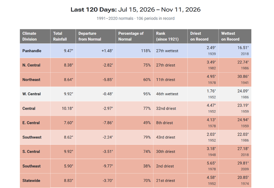
Over the past 120 days dating back to mid-July, rainfall totals highlight a stark divide across the state. Parts of the far western Panhandle have recorded more than 13 inches of rain, while far southeast Oklahoma has received less than 4 inches—leaving that region nearly 12 inches below normal for the period. The prolonged deficit is also taking a visible toll on area lake levels across eastern and southeastern Oklahoma.
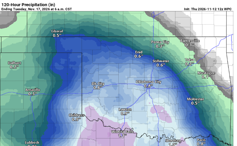
More rain is in the forecast through the weekend, bringing welcome relief to parts of the state. However, McManus noted that the upcoming rainfall may largely miss the hardest-hit areas of eastern Oklahoma, leaving communities there looking toward next week for their next chance at meaningful moisture.
Meanwhile, in the tropical Pacific, the developing El Niño—colloquially referred to as a “Super” El Niño—has officially crossed into the “very strong” category. According to data from the Climate Prediction Center (CPC), the three-month sea surface temperature anomaly reached +2.0°C for the August–October period, following steady increases from +1.0°C in May–July, +1.4°C in June–August, and +1.7°C in July–September.
The CPC classifies El Niño strength using the following thresholds:
- Strong: +1.5°C to less than +2.0°C
- Very strong: +2.0°C or higher
- Historic: +2.5°C or higher (exceeding the previous record)
Updated CPC probabilities show a 100% chance of a very strong El Niño continuing through the October–December period, a 96% chance for November–January, and a 79% chance for December–February. However, the likelihood of the event reaching “historic” record-breaking levels during the late fall or early winter has dipped from roughly 83% in October’s outlook to about 60%.
“CPC is still expecting an extraordinary El Niño, but the forecast distribution has shifted downward enough to make a new record a bit less certain,” McManus noted.
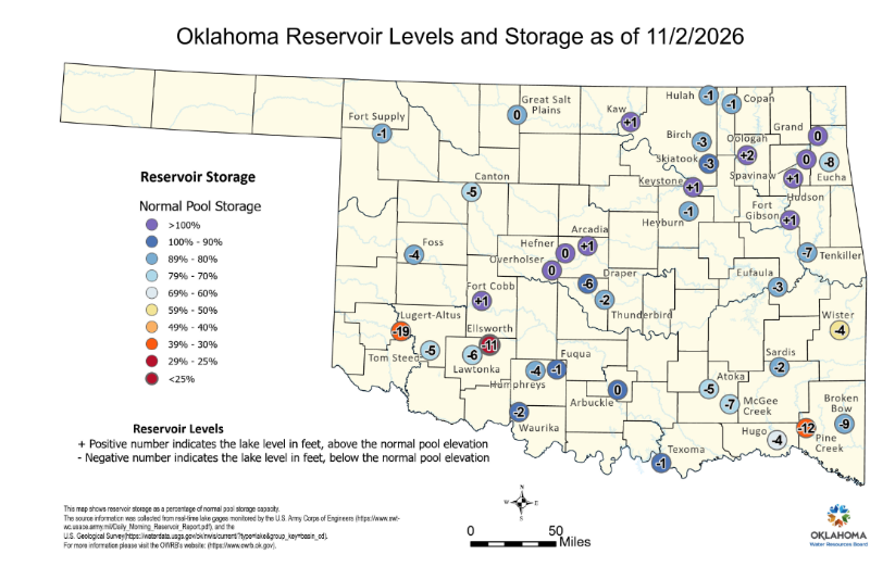
McManus noted that the prolonged moisture deficit is clearly reflected in reservoir levels across eastern and southeastern Oklahoma, which point to a longer-lived drought in that part of the state. Current U.S. Army Corps of Engineers and state gauge readings show several major eastern and southeastern reservoirs sitting well below normal conservation pool elevations:
- Broken Bow Lake: 589.88 feet, or 12.62 feet below its 602.5-foot full pool
- Lake Tenkiller: 625.13 feet, or 6.87 feet below its 632-foot full pool
- Hugo Lake: 400.24 feet, or 4.26 feet below its 404.5-foot full pool
- Wister Lake: 473.85 feet, or 4.15 feet below its 478-foot full pool
- Lake Eufaula: 581.47 feet, or 3.53 feet below its 585-foot full pool
- Grand Lake O’ the Cherokees: 742.02 feet, or 2.98 feet below its 745-foot full pool
For Oklahoma’s upcoming winter weather, McManus emphasized that whether the index ultimately peaks just below or just above the record threshold makes little practical difference. Both outcomes represent a powerful atmospheric forcing that is already influencing fall weather patterns via a tropical Pacific connection.
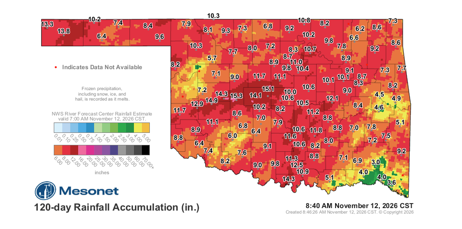
“The strength of an El Niño doesn’t mean the typical impacts will be stronger, but that the typical impacts will be more likely,” McManus explained. While Oklahoma has not yet seen southern-track storm systems arriving every few days, the tropical connection has already begun to shape the state’s fall moisture pattern. To read more from Gary McManus in his mesonet ticker, click here: