

To view the latest Oklahoma drought map, CLICK HERE.
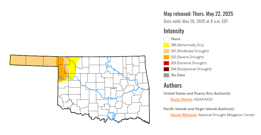
According to the latest Oklahoma drought monitor report, exceptional drought remains at zero percent, unchanged from the start of the calendar year.
Extreme drought or worse conditions remain at zero percent, unchanged since the week of October 29, 2024.
Severe drought or worse conditions are unchanged from 2.99 percent last week.
Moderate drought or worse conditions are unchanged from 11.94 percent last week.
Abnormally dry or worse conditions are unchanged from 15.52 percent last week.
According to the 6-to-10-day precipitation outlook map, the panhandle of Oklahoma, along with the Southwestern third of the state, is leaning above 40-50% chances of precipitation through May 31. A band stretching from the Northwest to the Southeast is leaning above 33 – 40% chances of precipitation. The North Central, Northeastern and Eastern portions of the state are near normal chances of precipitation through May 31.
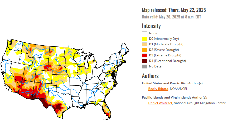
To view the United States Drought Map, CLICK HERE.
This week, widespread precipitation impacted much of the U.S., with heavier amounts (exceeding 1 inch) observed from the northern Rockies eastward to the East Coast, and in portions of the Pacific Northwest, Hawaii, and southern Alaska. Specifically, much of the High Plains reported 2 to 10 inches of rain, while similar totals (2 to 8 inches) were seen across parts of the South, Midwest, and along the East Coast. This above-normal precipitation supported drought improvements across large portions of the High Plains and Northeast, parts of the Midwest and Southeast, and smaller pockets of the West and South. Conversely, below-normal weekly precipitation occurred in parts of the western U.S., the Midwest, and Southeast, leading to the expansion or intensification of drought and abnormal dryness in western High Plains, eastern West, and parts of the Midwest and Southeast. Temperatures were above normal across much of the U.S. this week. The southern U.S., from Texas to Mississippi, saw temperatures up to 10 degrees F above normal. In contrast, below-normal temperatures, with departures up to 10 degrees F below normal, were observed across much of the West and western High Plains, with the largest departures noted in the Dakotas and interior West.
In the Southern Plains, warmer temperatures dominated this week, with departures ranging up to 10 degrees F above normal. However, parts of Texas and Oklahoma observed temperatures near or below normal this week. Precipitation varied across the region this week, with heavier amounts (2 to 8 inches) falling across much of Arkansas, eastern Oklahoma, and in parts of Tennessee, northern Mississippi, and small parts of Texas. Unfortunately, not many improvements were made due to rain falling over areas already free of drought and abnormal dryness, but conditions prevent existing drought from expanding or intensifying. Moderate drought (D1) was removed from eastern Tennessee this week, while abnormal dryness (D0) was removed from Mississippi and improved in eastern Tennessee. Arkansas, Louisiana, and Mississippi are free of drought and abnormal dryness this week.
In the High Plains, temperatures varied this week, with departures ranging up to 8 degrees F above normal, while cooler-than-normal temperatures were observed along the western and northern portions of the region. Heavy precipitation fell across much of the region this week, with areas from North Dakota to northern Nebraska reporting weekly precipitation totals between 400% to 600% above normal. These beneficial rains (2 to 8 inches above normal) justified widespread moderate to extreme drought (D1-D3) improvements in the Dakotas and Nebraska. Additionally, improvements of moderate to severe drought (D1-D2) and abnormal dryness (D0) occurred in northern Wyoming and eastern Kansas, where rainfall amounts were up to 3 inches above normal for the week. Conversely, dry conditions resulted in the expansion of extreme drought (D3) in southwest Nebraska and western Wyoming, while severe (D2) and moderate drought (D1) expanded in southern Wyoming and Colorado. Abnormal dryness was also expanded in eastern Colorado this week.
In the West, Cooler temperatures dominated the West this week, with departures ranging between 1 to 10 degrees F below normal. Much of the interior West experienced temperatures between 4 to 10 degrees below normal. In contrast, above-normal temperatures were observed across the eastern portions of the Southwest and in parts of Montana, eastern Utah, southern Nevada, and northern California. Precipitation varied across the region this week, with beneficial amounts falling in parts of the Southwest and northeastern Oregon. Moderate to extreme drought (D1-D3) were improved in eastern New Mexico, while moderate to severe drought (D1-D2) were trimmed back in western Utah and abnormal dryness (D0) was improved in Oregon. Conversely, below-normal precipitation resulted in the expansion of exceptional drought (D4) in southwestern New Mexico and moderate drought (D1) in northern Montana this week.
Looking ahead, during the next five days (May 20–24, 2025), as the medium range period begins Tuesday, a surface low-pressure system over the Mid-Mississippi Valley supported by strong upper-level energy will provide ample lift and instability for rain and thunderstorms in the Mississippi and Ohio Valleys. The low is forecast to track east and spread rain and thunderstorm chances to the Mid-Atlantic in particular on Wednesday, and shifting into the Northeast later week as the low pivots northward. Elsewhere, some weak troughing aloft and frontal systems tracking through the Northwest next week could produce rounds of modest precipitation there. Most precipitation should be rain aside from the highest peaks. Warm to hot temperatures are likely across the southeastern U.S. as the subtropical upper ridge reaches the region. Southern Texas in particular will remain hot into Tuesday, with temperatures well into the 100s. The Florida Peninsula should see warm temperatures in the mid 90s. Both areas could see record or near-record warm lows and highs. Meanwhile, a trough will promote below normal temperatures across the northern tier, with highs only reaching the 50s in the north-central Plains on Tuesday. As the trough tracks east, cooler than average temperatures are likely in the eastern third of the U.S. under it, moderating temperatures in the South. But upper ridging poking into the southwestern U.S. will raise temperatures to above normal there, expanding east across the Four Corners states by Thursday and into the southern Plains late next week. Highs will be well into the 100s in the Desert Southwest with temperatures nearing 100 in parts of Texas eventually.
The Climate Prediction Center’s 6-10 day outlook (valid May 25–29, 2025) favors above-normal precipitation across most of the U.S., with near-normal precipitation favored from southern California to Montana, as well as parts of the Midwest, northern New England, and northwest Alaska. Below-normal precipitation favored in portions of the Midwest, from northern Minnesota to northern Michigan. Increased probabilities for above-normal temperatures are forecast for Hawaii, much of the West, and along the Gulf, while below-normal temperatures are favored from the central Plains to the Northeast, and in parts of Alaska.
To view the 6-10 Day Precipitation Outlook Map, click here.
To view the 6-10 Day Temperature Outlook Map, click here.
To view the Monthly Drought Outlook Map, click here.


