

To view the latest Oklahoma drought map, CLICK HERE.
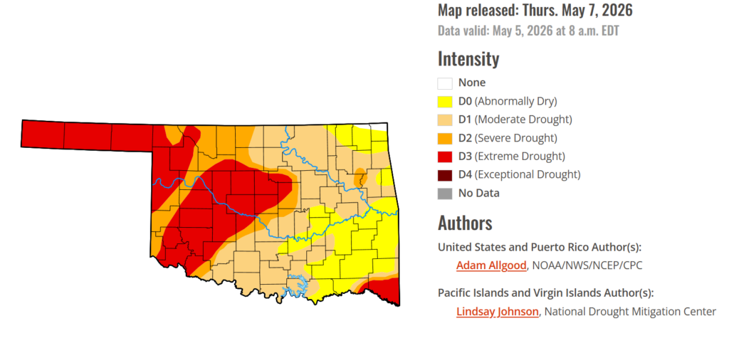
Oklahoma’s drought story continues to move in two very different directions, with southeastern parts of the state seeing gradual improvement while western Oklahoma slips deeper into extreme drought. The latest U.S. Drought Monitor shows more than 80 percent of the state remains in drought, with extreme drought expanding across much of western Oklahoma this week. Recent rains are helping ease conditions in the southeast, but western rangeland and winter wheat areas continue to struggle. Even with above-normal rain chances in the outlook through mid-May, the divide between eastern relief and western stress remains firmly in place.
According to the latest Oklahoma Drought Monitor report, exceptional drought remains at 0 percent, unchanged from the start of the calendar year.
Moderate to extreme drought conditions in the current period indicate that 80.63% of the state is affected by drought, equal to last week.
Southeastern Oklahoma is seeing drought conditions ease, except in McCurtain County, where extreme drought lingers in the south, with other areas shifting into the lower drought tier of abnormally dry conditions.
Extreme Drought conditions have increased this week by 3.77%, covering 30.85% of the state, affecting a majority of western Oklahoma.
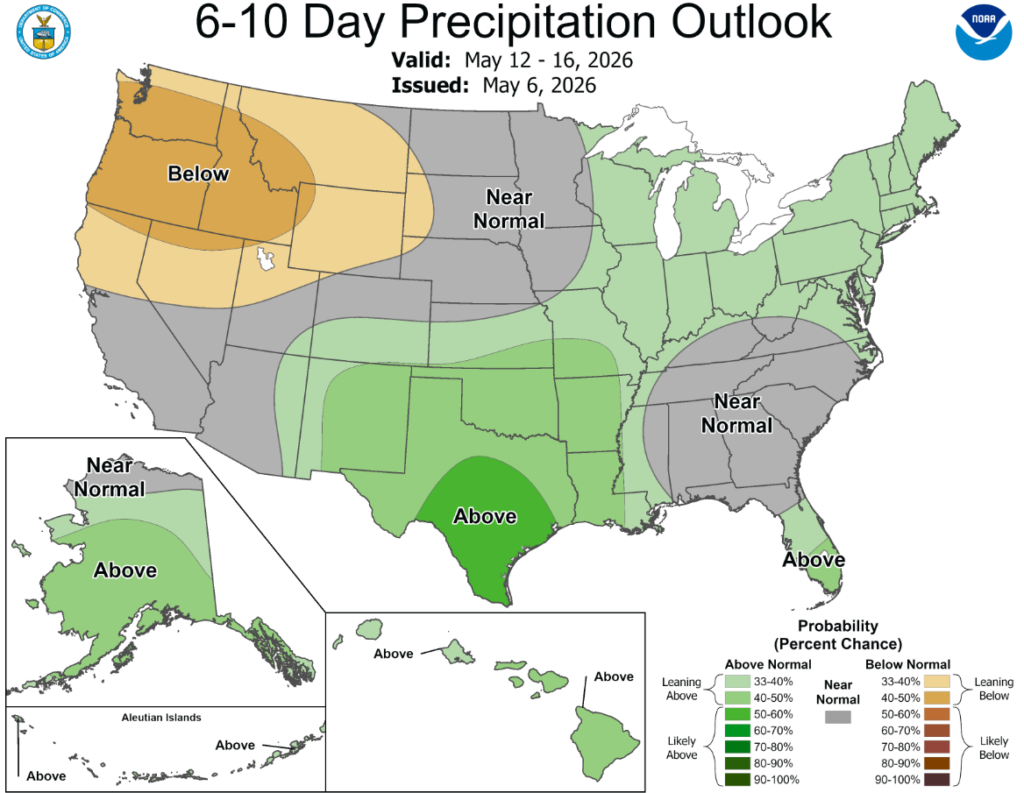
According to the 6-to-10-day precipitation outlook map, all of Oklahoma is leaning above 40-50% chance of precipitation through May 16th.
Widespread soaking rains fell across Texas and the Deep South, bringing a much needed moisture boost to these drought stricken areas. While sufficient to ease drought conditions across portions of Texas, the lower Mississippi Valley, and the Tennessee Valley, drought conditions remained mostly unchanged across southeastern Alabama, Georgia and northwestern Florida, where soil moisture and streamflows remain extremely low. Lighter rainfall also overspread the Northeast, which, combined with cooler temperatures helped slow the advancement of drought, and improved drought conditions in Maine. Where lighter accumulations occurred, there was slight expansion of drought and abnormal dryness across portions of the mid-Atlantic, Hudson Valley, and southeastern New England. Cooler temperatures and mostly dry weather overspread the Plains and Midwest. While drought conditions continued to expand across the Plains, the drier weather was mostly welcome across the upper Midwest and Corn Belt, allowing fieldwork to progress. Hot, dry weather promoted degradation across Arizona and northwestern Washington, while late season moisture across northern California did little to change the meager snowpack conditions.
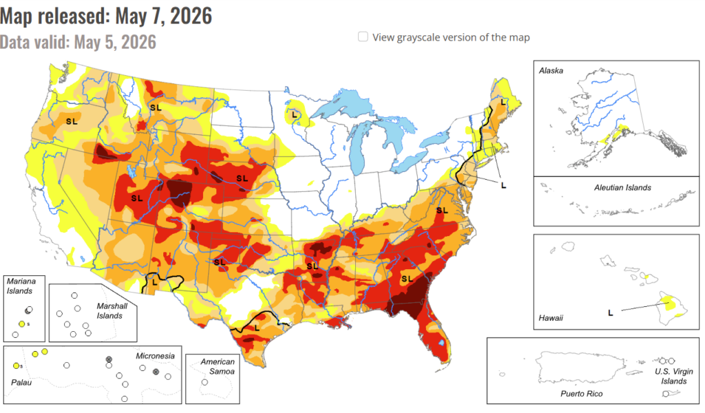
In the South: Following last week’s beneficial rainfall, additional rain overspread much of Texas and Louisiana over the last several days, sparking additional drought reductions. Rainfall across central and western Texas eased drought across the upper Rio Grande Valley as well. Despite the beneficial rainfall, widespread severe to exceptional drought continues across the South Region, and it will take a sustained series of heavy precipitation events to begin any widespread easing of impacts. The beneficial rainfall missed the Texas Panhandle and western Oklahoma, where poor conditions continue to affect rangeland and winter wheat. Drought conditions also expanded across Arkansas.
In the High Plains: Light to moderate precipitation overspread much of the High Plains, with the heaviest accumulations (0.5 – 1.5 inch) falling across central Colorado, including late season snow across the higher elevations. This precipitation resulted in some drought reduction across central Colorado. Across the rest of the Plains, however, the moisture was not sufficient to engender substantive improvements. Despite cooler temperatures lowering evapotranspiration rates, some degradation occurred across Kansas and Nebraska, and far western North Dakota.
In the West: Outside of northern California, where late season moisture provided a boost to short-term streamflows and soil moisture but did little to change the unusually low snow cover across the northern Sierras, seasonably dry weather overspread most of the West. Recent moisture eased drought conditions across far western Montana. While little change to the drought depiction occurred across the West, hot, dry conditions exacerbated impacts across Arizona, resulting in some substantial degradation. Short term dryness also increased across northwestern Washington, resulting in expansion of D0.
To view the 6-10 Day Precipitation Outlook Map, click here.
To view the 6-10 Day Temperature Outlook Map, click here.
To view the Monthly Drought Outlook Map, click here.


