

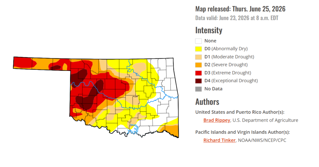
To view the latest Oklahoma drought map, CLICK HERE.
As Oklahoma moves deeper into summer, drought continues to shape conditions for producers across the state. Although eastern Oklahoma has seen improving moisture, severe dryness in the west is still driving higher input costs, stressing pastures, and adding pressure to already difficult production decisions.
According to the latest Drought Monitor, exceptional drought persists in parts of western Oklahoma, including Kiowa County, Ellis County, Beaver County, Woodward County, and surrounding areas. Historic impacts of exceptional drought include rising hay and water costs, limited supplies, and herd liquidation by producers. Ranchers and farmers are facing severe economic losses as failed crops are baled or abandoned, pastures turn bare, and cracked, dry land leaves some fields unusable. An exceptional drought currently covers 7.13% of the state, equal to last week.
Moderate to extreme drought conditions in the current period indicate that 53.43% of the state is affected, down 8.85% from last week. At this point, 22.17% of the state remains drought-free, up 3.83% from last week.
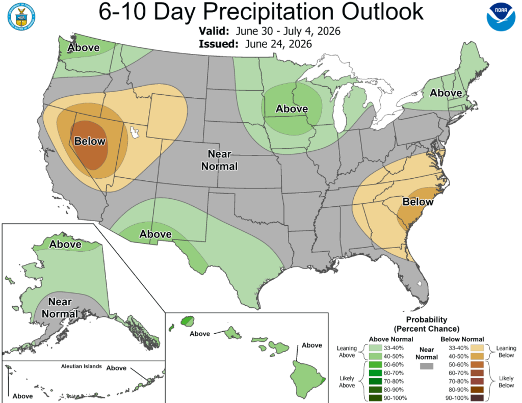
According to the 6-to-10-day precipitation outlook map, Oklahoma is expecting near-normal conditions through July 4th.
Tropical Storm Arthur briefly formed near the middle Texas coast on June 17, hours before wobbling inland near Galveston. However, a precursor low-pressure system delivered heavy rain in parts of southern Texas, followed by a post-tropical deluge from the central Gulf Coast region into the lower Southeast. Totals of 4 to 8 inches or more were common across the Deep South, with higher amounts observed in several spots. Although flash flooding and lowland flooding occurred, overall impacts were muted by antecedent drought, which until recently had spanned the South. Farther north, a series of cold fronts sparked occasional showers and thunderstorms, resulting in localized wind and hail damage but maintaining favorable soil moisture reserves for most Midwestern summer crops. The Plains also received scattered showers, amid variable impacts related to lingering drought on rangeland, pastures, and summer crops. Meanwhile, the Plains’ winter wheat harvest quickly advanced between showers, as the drought-affected crop dried down ahead of the normal pace. In the western U.S., hot, mostly dry weather prevailed. Complications related to Western heat included heavy irrigation demands and a broadly elevated wildfire threat. One of the region’s most significant wildfires, the Iron Fire near Eureka, Utah, ignited on June 19 and quickly burned more than 37,000 acres of grass and chaparral.
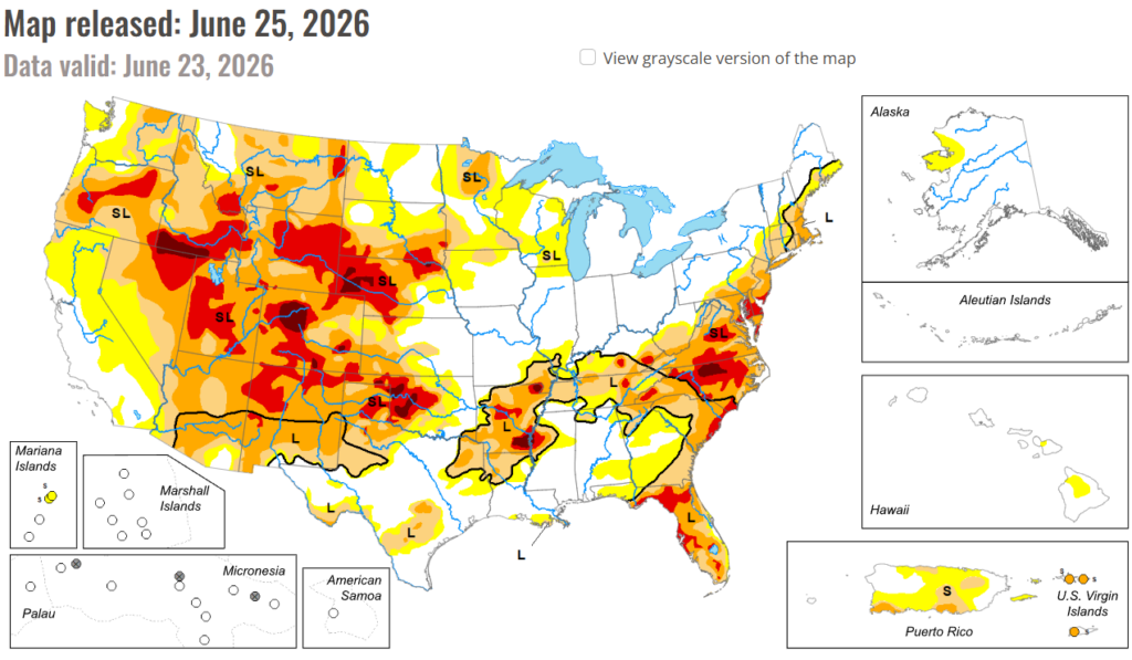
In the South: Downpours related to frontal interactions with tropical moisture, including Tropical Storm Arthur, delivered drought relief but caused local flooding. In fact, the western and central Gulf Coast regions became mostly drought-free, following the latest deluge, with broad one-category improvement noted from eastern Texas into central and southern Alabama, as well as northern Arkansas and western Tennessee. By June 21, with periods of heavy rain still falling, statewide topsoil moisture in agricultural regions had increased to 35% surplus in Louisiana, according to the U.S. Department of Agriculture. The region’s most significant remaining drought existed across parts of Arkansas and environs, along with the northwestern half of Oklahoma.
In the High Plains: The region’s eastern states reported drought improvement or unchanged conditions, with a few exceptions. Streaks of heavy rain led to one-category improvement in a swath across central Nebraska and western and central Kansas. However, the rain arrived too late to help winter wheat and has only recently begun to revive drought-stricken rangeland and pastures. With the winter wheat harvest well underway (40% complete, nationally, on June 21), 46% of the crop was rated in very poor to poor condition. More than one-half of the crop was rated very poor to poor in Nebraska (83%), Colorado (63%), and Kansas (55%). On June 21, statewide rangeland and pastures were rated at least one-half very poor to poor in Nebraska (73%), Colorado (63%), and Wyoming (60%). In contrast to areas farther east, drought deterioration was observed in parts of Colorado and Wyoming.
In the West: Hot, dry weather boosted irrigation demands and resulted in a broadly elevated wildfire threat. Drought deterioration was commonly observed across roughly the northern half of the region, amid significantly above-normal temperatures and mounting water-supply concerns. However, water supplies are highly basin-dependent and often complicated by water rights and other local, state, or regional regulations. Some of the West’s most significant drought—with embedded pockets of extreme to exceptional drought (D3 to D4)—stretched from Oregon to Wyoming, southward into portions of the Four Corners States. By June 24, at least a half-dozen active Western wildfires had burned more than 10,000 acres of vegetation—three in Utah, two in Nevada, and one in Washington. Additionally, the U.S. Department of Agriculture reported on June 21 that statewide rangeland and pastures were rated 75% very poor to poor in Arizona, along with 63% in Colorado, and 60% in Wyoming.
To view the 6-10 Day Precipitation Outlook Map, click here.
To view the 6-10 Day Temperature Outlook Map, click here.
To view the Monthly Drought Outlook Map, click here.


