The threat of a rapidly intensifying King Kong El Niño is developing in the Pacific, carrying the potential to drastically alter weather patterns across the southern plains. However, Oklahoma must first navigate a forecasted period of below-normal precipitation through the core summer months. State Climatologist Gary McManus detailed the severe atmospheric shifts impacting the region, analyzing everything from recent localized destructive storms to the long-term seasonal outlook.
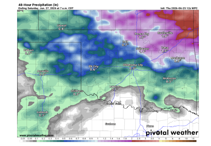
The state recently experienced a wild stretch of weather, including a powerful derecho that packed a 102-mile-per-hour wind gust recorded at an Oklahoma Mesonet site. Additionally, localized rainfall totals have been staggering, with radar indicating over a foot of rain in parts of Osage County within a single six-hour window. While these events help alleviate long-term moisture deficits, they present a stark contrast to the upcoming seasonal outlook.
Understanding the Looming King Kong El Niño
The climate conversation has quickly shifted toward the intensity of the current oceanic warming trends.
“Right now, the atmospheric oceanic coupling shows a weak El Niño,” Gary McManus explained. “And it is expected to get to the strong to very strong category. Very strong is not the common term that people like to use. Some say super strong, some will start to name it something like Godzilla, but we’ve already used Godzilla back in 2015. So maybe, maybe this would be the King Kong El Niño.”
According to McManus, historical data dating back to the 1950s suggests this developing system could rank among the most powerful on record. While it is currently active, its true structural strength and subsequent impacts are projected to amplify later in the year.
“As we look forward through the summer into the fall, that’s when it’s expected to strengthen and start having those impacts in our part of the globe,” McManus noted.
Summer Drought Restrictions vs. Winter Moisture
Despite the looming presence of a historic King Kong El Niño, Oklahomans should not expect immediate summer rainfall. The Climate Prediction Center’s long-range forecasts for July through September indicate increased odds of below-normal precipitation for the southern plains, encompassing the southern half to two-thirds of Oklahoma.
“That certainly flies in the face of anybody thinking that El Niño’s going to have an impact this summer for Oklahoma,” McManus cautioned. “A normal Oklahoma summer, what we would expect, would be the rain start to taper off as we get here to the end of June, and really start to shut off a little bit more as we get into July and even more so in August, and that heat to ramp up.”
The beneficial impacts of El Niño typically delay until late autumn and winter for this region. Historically, a strong system brings cooler and wetter conditions on average from mid-fall through early spring—specifically from October or November through March or April.
A stronger climate signal does not automatically guarantee extreme weather, but it heavily tilts the odds. McManus pointed out that a strong system increases the likelihood of typical impacts, potentially raising the probability of a wetter-than-normal cool season from 66% to 75%.
Historical Precedent: The 2015 Godzilla Paradigm
To understand the potential impact of a massive El Niño, agricultural producers often look to the historic 2015-2016 cycle. That particular system triggered the wettest year on record for Oklahoma.
“It actually formed early in the spring of 2015, which is sort of unusual, just like this year,” McManus recalled. “But it was very strong back then, and it helped sort of give us a little impetus for that wettest May on record in the state of Oklahoma back in 2015. In fact, it was the wettest month ever in the history of the state of Oklahoma.”
That same cycle produced the state’s second-wettest November and wettest December. While these setups bring substantial moisture that benefits long-term soil reserves, they also carry severe risks of flooding and property damage.
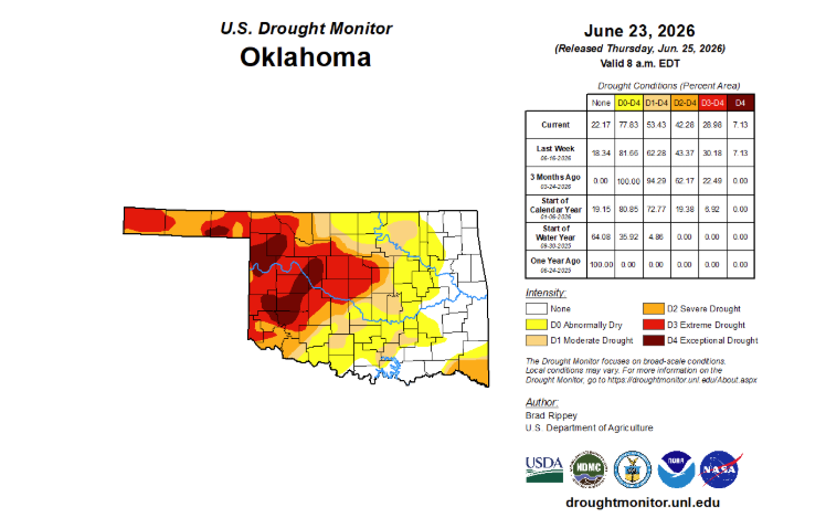
Current Drought Status and Agricultural Concerns
The prospective moisture cannot arrive soon enough for western portions of the state. The latest U.S. Drought Monitor indicates that more than half of Oklahoma remains in at least moderate drought, with roughly 40% in severe, extreme, or exceptional drought.
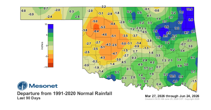
Long-term moisture deficits across the Panhandle, west-central, and central Oklahoma persist. Many areas report rainfall deficits of 6 to 8 inches over the past 90 to 180 days. This lack of moisture was compounded by periods of record-breaking warmth over the past year, accelerating evaporation and crop stress.
“That did a lot of damage, so it’s going to take a lot of rainfall to get out of that drought in that part of the state,” McManus emphasized. “We just continue to miss out on those widespread heavy rains in that part of the state.”
As the state enters the hottest months of the year, the primary concern is whether western Oklahoma will experience worsening conditions before the seasonal benefits of El Niño finally arrive.
“Western Oklahoma and up there in the Panhandle, they need rainfall as the eastern half has seen already,” McManus concluded. “Because if you have that sort of drought going into a hot summer, then we might be in trouble out there.”