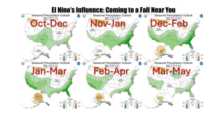
Oklahoma producers and residents weary of persistent summer heat and dry conditions may soon see a significant shift in regional weather patterns. Oklahoma State Climatologist Gary McManus reports that a strengthening, potentially historic El Niño in the equatorial Pacific could bring cooler temperatures and increased moisture to the state as the region transitions into late fall and winter.
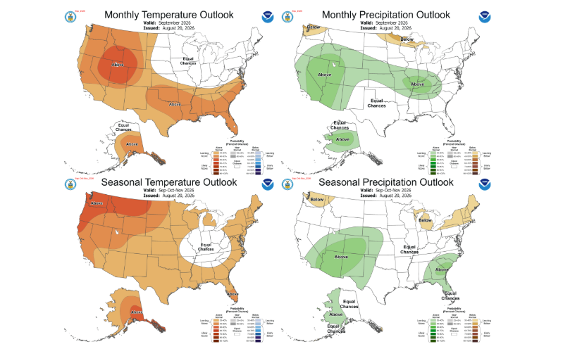
While the pattern offers promise, McManus emphasized that El Niño impacts typically take time to establish across the Southern Plains. Early fall forecasts from the Climate Prediction Center (CPC) indicate that above-normal temperatures will likely linger through September, delaying an immediate shift.
Fall Outlook: A Battle of Trends
The CPC outlook for September through November shows the signature El Niño moisture signal attempting to spread eastward across the region. However, two primary factors are moderating confidence for widespread heavy rainfall across the entire Southern Plains early in the season:
- Climatological Dry Trends: Recent autumn trends across the eastern Plains and Lower Mississippi Valley have favored drier-than-normal conditions, working against typical El Niño patterns.
- Pattern Timing and Analogs: Historical analog models for this specific eastern-Pacific El Niño suggest that the classic southern-tier wet pattern may develop later in the fall rather than establishing immediately in September.
Because September typically carries a neutral signal, its inclusion in the three-month average keeps precipitation chances broader. McManus noted that as the region advances into October and November, the wetter impacts should become more pronounced across the state.
Winter Potential and Historical Probabilities
As autumn progresses into winter, the strengthening El Niño is projected to exert a much firmer grip on North American weather patterns. The CPC favors wetter-than-normal conditions expanding across the southern tier and central Plains, while drier conditions prevail across the northern Rockies and Great Lakes.
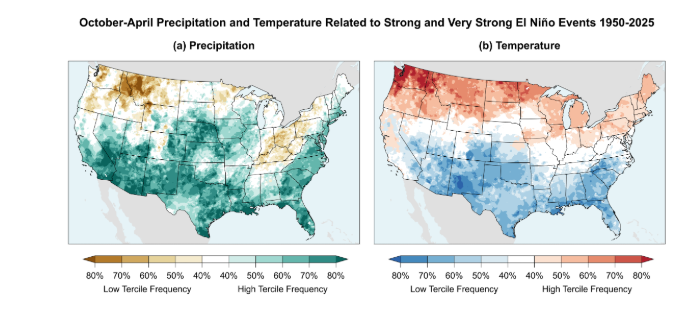
Historically, strong to very strong El Niño events have significantly favored Oklahoma agriculture and water resources during the cool season. Looking at October through April data during strong El Niño events dating back to 1950:
- Precipitation: Oklahoma has ranked in the wettest third of historical years roughly 60% to 80% of the time.
- Temperatures: Regional temperatures have fallen into the coolest third of historical records approximately 60% to 70% of the time.
While these historical trends represent probabilities rather than a guaranteed forecast, the pattern stands in sharp contrast to recent La Niña regimes, generally signaling reduced drought pressure, moderated heat, and lower wildfire danger through the winter months. By spring, the El Niño pattern is expected to gradually weaken and retreat.
OK-FIRE Educational Workshops Expand
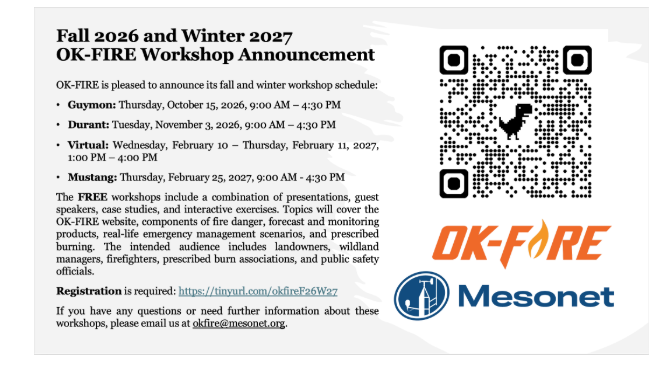
In addition to monitoring long-term weather shifts, Oklahoma’s OK-FIRE program has announced expanded in-person educational workshops. In addition to traditional fall dates, workshop sessions will now be offered in February to assist agricultural producers, land managers, and emergency personnel with fire weather monitoring and planning.