

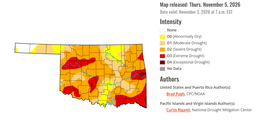
To view the latest Oklahoma drought map, CLICK HERE.
Exceptional drought in Oklahoma has taken a significant step backward this week, offering some relief after months of widespread dry conditions across the state. The latest improvement marks a notable shift in the drought picture, although much of Oklahoma continues to face lingering moisture deficits.
According to the Drought Monitor, exceptional drought has decreased significantly this week, now covering 0.80% of the state compared to 7.10% last week.
Moderate to extreme drought conditions in the current period affect 86.39% of the state. At this point, 3.12% of the stat has no drought conditions.
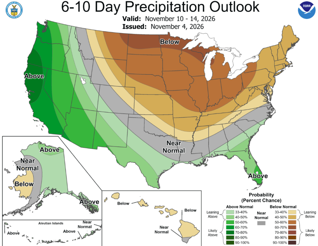
According to the 6-to-10-day precipitation outlook map, Oklahoma is leaning below a 33-50% chance of rain through November 14th.
The very wet fall continued across the southwest quarter of the contiguous U.S. to end October. Based on the additional heavy precipitation (more than 1 inch) from October 27-November 2 and a positive shift in the long-term metrics since September, a broad 1-category improvement was made to the Southwest and Great Basin. Although short-term drought has ended, lingering long-term drought remains designated for parts of these areas. The remnants of Hurricane Vance from the East Pacific brought drought-improving precipitation to western and central Texas. At the start of November, heavy precipitation prompted improvements to the Great Plains and Upper Mississippi Valley. Drought coverage continued its late summer and fall decline across Florida. Drought expanded and intensified for parts of the Lower to Middle Mississippi Valley, Ohio Valley, Mid-Atlantic, and New England. Alaska and Hawaii remain drought-free, while drought continues to improve across Puerto Rico.
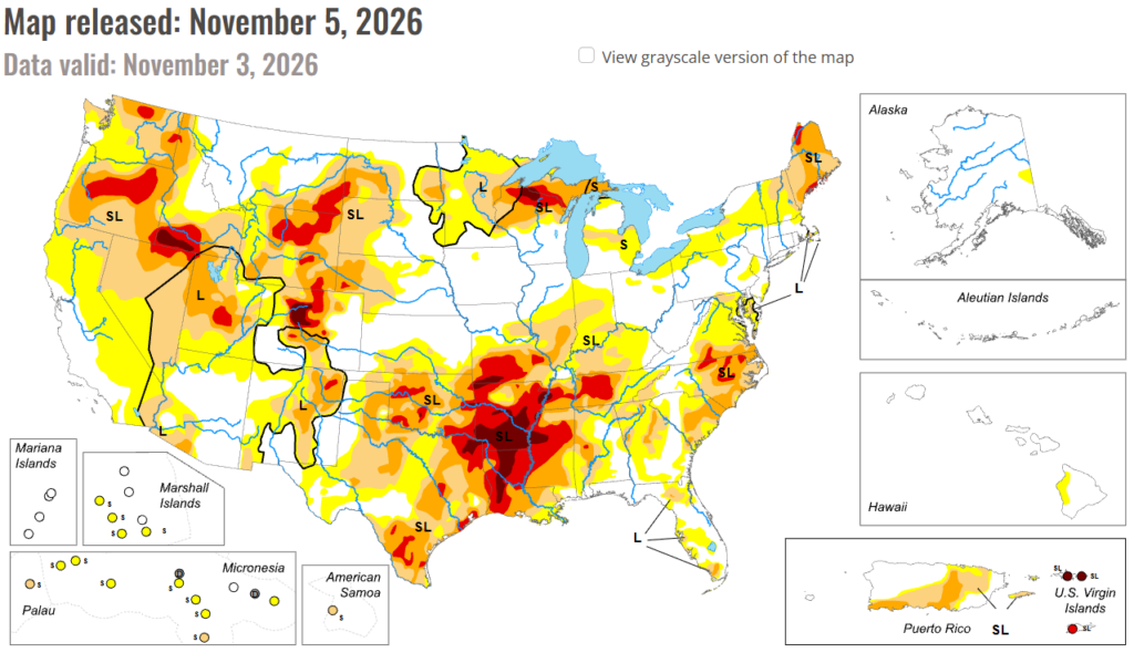
In the South: The remnants of Hurricane Vance in the East Pacific brought heavy rainfall to western and central Texas. A 1-category improvement was made roughly to areas that received more than 1 to 1.5 inches of rainfall. Also, SPIs at various time scales were considered. The unusually wet fall continued in New Mexico where a broad 1-category improvement was necessary. Additional improvements may be needed in subsequent weeks to be more consistent with long-term metrics. Please note that short-term drought has ended for New Mexico. Near or more than one inch of precipitation supported improvements across the western third of Oklahoma. Since this precipitation occurred on November 2nd, additional improvements may be made to a greater coverage of Oklahoma next week once a full assessment of the latest metrics is completed. The D2, D3, and D4 coverage across Arkansas, Louisiana, Mississippi, and Tennessee is generally consistent with SPEIs at various time scales and soil moisture indicators. Impact reports from Mississippi include poor to very poor pastures along with dry farm ponds. The lack of precipitation the past two months (60-day deficits of more than 4 inches) coupled with above-normal temperatures (+6 to 10 degrees F since early September) has led to rapid intensifying drought across the Lower Mississippi Valley. Heavy precipitation (1.5 to 2 inches, locally more) resulted in a 1-category improvement to southwestern Tennessee and northern Mississippi, while a 1-category degradation was warranted for northeastern Tennessee.
In the High Plains: Widespread precipitation (0.5 to 2 inches, locally more) resulted in 1-category improvements to the western third Colorado along with parts of the Northern to Central Great Plains. Recent precipitation and the “convergence of evidence” supported discontinuing the D3 in most of the Nebraska Panhandle.
In the West: A low pressure system at an unusually low latitude for this time of year resulted in anomalously wet conditions across southern California and the Desert Southwest over Halloween weekend. During the past 60 days, precipitation has averaged well above normal (200 to 400%, or more) across southern California, southern Nevada, and most of Arizona and Utah. This fall wetness is related in part to the El Nino driven active tropical cyclone season in the East Pacific. Precipitation amounts of more than one inch prompted a 1-category improvement from Arizona north to Nevada, Utah and southeastern Idaho. Please note that short-term drought has ended for the Southwest and Great Basin. Despite multiple short-term metrics on the wet side, long-term drought of varying intensity persists across parts of these areas. Precipitation (0.5 to 1 inch, locally more) this past week led to small improvements for parts of Montana. Drought coverage and intensity remained steady for the Pacific Northwest and much of California.
To view the 6-10 Day Precipitation Outlook Map, click here.
To view the 6-10 Day Temperature Outlook Map, click here.
To view the Monthly Drought Outlook Map, click here.