
Oklahoma ranchers and agricultural producers could soon see welcome relief from prolonged drought as a strong El Niño pattern takes hold across the Pacific, according to USDA Chief Meteorologist Brad Rippey. Speaking to farm broadcasters during the National Association of Farm Broadcasters (NAFB) Convention, Rippey outlined how shifting ocean temperatures are reshaping the U.S. weather outlook through the summer of 2027 while fielding questions on drought monitoring, pest pressures, extreme rainfall, and global crop impacts.
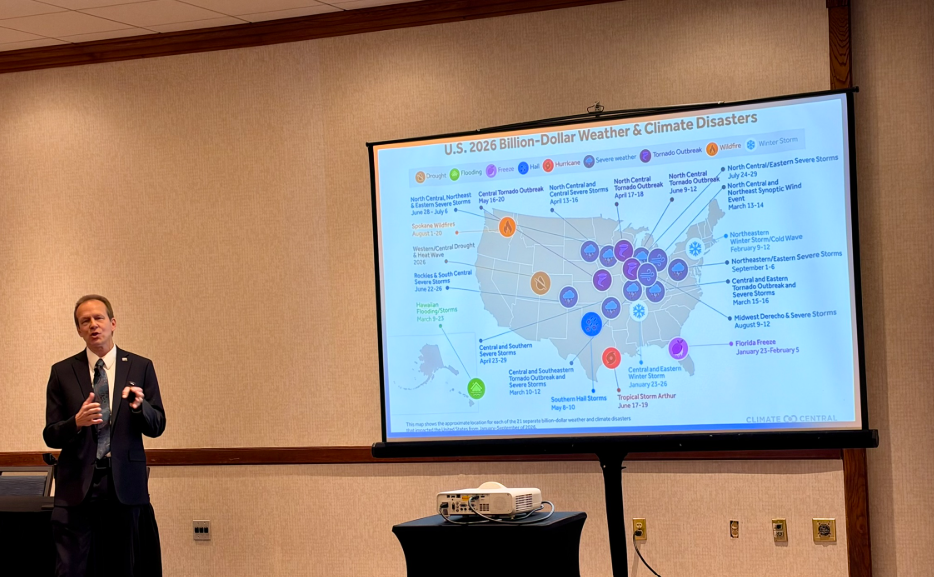
Rippey noted that the nation is emerging from a punishing stretch of weather that produced more than 20 billion-dollar disasters even before El Niño developed. Roughly two-thirds of those events were localized severe storms—including hail, derechos, high winds, and tornadoes—that shifted away from the traditional Great Plains “Tornado Alley” and concentrated across the Midwest.
“You can see there, a lot of those severe weather events—not on the Great Plains, not so much in the South, but really kind of shifted, as the Tornado Alley is not quite where it once was back across the Great Plains,” Rippey said.
Over the past year, persistent drought covered more than 40 percent of the country for over 12 consecutive months, peaking at 63 percent last spring and fueling nearly 9.5 million acres of wildfires nationwide—just shy of the all-time record of 10.1 million acres. Those dry conditions pushed national winter wheat abandonment above 32 percent, the second-highest rate since the Dust Bowl era.
“I think we’ll be a lot better this year with the moisture, with El Niño, and we’ll see if we can get that number back below 20 percent for the first time since 2016,” Rippey said. “I think it’s possible given the moisture improvement that we’re seeing across the Great Plains.”
Conditions have already begun to turn around as El Niño pushes moisture from the southwest to the northeast. U.S. winter wheat ratings jumped from 44 percent good-to-excellent earlier in the season to 53 percent, marking the highest rating for this time of year since 2018.
With equatorial Pacific waters running 6 to 7 degrees Fahrenheit above normal at the surface and up to 20 degrees above normal at depth, Rippey said El Niño is expected to reach peak strength within weeks. While he dismissed the media label “Super El Niño” as a clickbait term, he noted there is a roughly two-in-three chance this event will rank among the strongest since 1950, alongside 1982–83, 1997–98, and 2015–16.
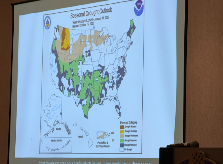
As atmospheric disruptions lag peak ocean warming by one to two months, Rippey expects a suppressed northern jet stream and an active, extended subtropical jet stream to steer frequent storms across Southern California, the Central and Southern Plains, and the Southeast. Nationally, drought coverage is projected to drop below 40 percent by the end of January 2027, with widespread drought improvement or eradication expected across the southern half of the country.
“Given the oceanic temperatures, until we see them starting to settle back down a little bit, we’re probably going to stay pretty warm,” Rippey said, noting that cold outbreaks across the northern U.S. will be weaker and shorter-lived than last winter, while dryness lingers across the Northern Rockies, Northern High Plains, Upper Midwest, and Great Lakes.
During an extended Q&A session with broadcasters from across the country, Rippey addressed several specific producer concerns heading into 2027:
- Spring Severe Weather and Wildfire Relief: Asked by Farm Director KC Sheperd whether winter moisture will curb the wildfires that plagued Oklahoma and the Plains, Rippey said a wet winter from Nebraska southward should reduce spring wildfire risks. However, he warned that as El Niño winds down in late winter and early spring, the Southern Plains and Southeast face an elevated risk of flooding and severe thunderstorms—mirroring the active spring severe weather season of 1998.
- Overwintering Pests and Crop Disease: Responding to questions about warm winter temperatures, Rippey cautioned that a lack of deep, prolonged freezes could prevent cold air from penetrating the soil to kill off insect populations. “You don’t get enough cold air penetrating into the soil, and then you get a rash, a wave of pest issues in 2027,” Rippey said, adding that persistent southwesterly winds could also carry fungal spores and crop diseases northward into the Corn Belt.
- Summer “Flash Drought” Risks: While recent decadal trends favor a protective dip in the jet stream that could keep the Midwest cool during the 2027 growing season, Rippey warned that long-range forecasts face high uncertainty across the “spring barrier.” He noted that past strong El Niños—such as 1983—were followed by rapid summer flash droughts during critical corn and soybean pollination windows, while the Pacific Northwest faces another hot, dry summer.
- Extreme Downpours and Soil Absorption: Asked by broadcaster Gill Cunningham of Champaign, Illinois, why rain increasingly falls in heavy bursts rather than steady all-day events, Rippey explained that a warmer atmosphere holds more moisture. “A warmer atmosphere can hold more moisture, and it does tend, especially in the convective season, the summer season, to rain out more quickly,” Rippey said. “How much actually reaches the soil and percolates in is less, so that does raise the risk of more drought even in times of normal precipitation.”
- Drought Monitor Delays and Vetted Data: When asked how producers can get faster drought designations in states like Oklahoma, Rippey praised Oklahoma State Climatologist Gary McManus as “the gold standard” while acknowledging that slight delays can occur between local conditions and national Drought Monitor updates. Rippey also urged broadcasters and farmers to avoid sensationalized social media weather maps and rely on vetted sources like the National Weather Service, USDA, and land-grant universities. “You’ve got to have a discerning eye when you look at stuff and just not believe everything you see,” Rippey said.
- Weather Balloon Cutbacks: Asked by Alan Watts of the Your Ag Edge Network in Kentucky about the restoration of off-hour weather balloon launches, Rippey confirmed that earlier cutbacks had temporarily reduced data feeding into computer forecast models, slightly affecting short-term accuracy, though he noted airplane wind and temperature reports help fill gaps over the Pacific.
Addressing global production, Rippey explained that because El Niño peaks during the Southern Hemisphere’s summer growing season, its immediate agricultural impact will be felt strongest in South America. In Brazil, El Niño typically produces dry weather in the north and wet conditions in the south—a split that often balances out national soybean and corn yields—while Argentina is expected to see favorable growing conditions.
“From an agricultural standpoint, the answer is Brazil, because from the equator southward—or really from the entire part of Brazil southward—it is the growing season,” Rippey said. “So for North America, and for the U.S. in general, most of the impacts are fall, winter, spring.”