

To view the latest Oklahoma drought map, CLICK HERE.
Oklahoma’s drought picture remains stubbornly locked in place, with nearly the entire state still dealing with some level of dryness as spring planting season moves forward. While extreme drought continues to grip many counties, forecasters are offering a bit of encouragement with better rain chances showing up across parts of the state in the days ahead. For producers and rural communities alike, the next round of moisture could make an important difference.
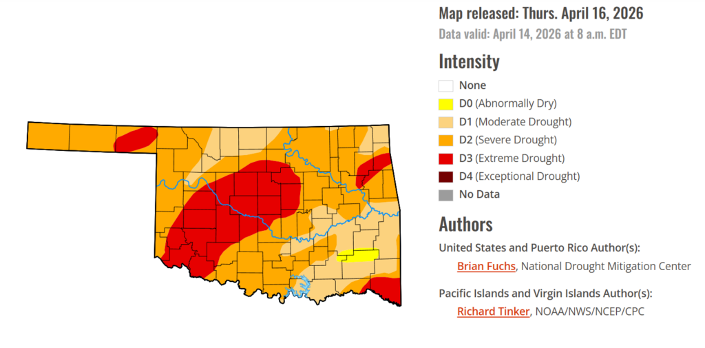
According to the latest Oklahoma Drought Monitor report, exceptional drought remains at 0 percent, unchanged from the start of the calendar year.
Moderate to extreme drought conditions in the current period indicate that 98.77% of the state is affected by drought, unchanged from last week.
Extreme Drought conditions have remained unchanged this week, covering 26.25% of the state, affecting mainly Blaine, Tillman, Pottawatomie, Seminole, McClain, Garvin, Stephens, Kiowa, Washita, Delaware, Ottawa, Mayes, Cherokee, McCurtain, oklahoma candiaian, Kingfisher, and parts of surrounding counties.
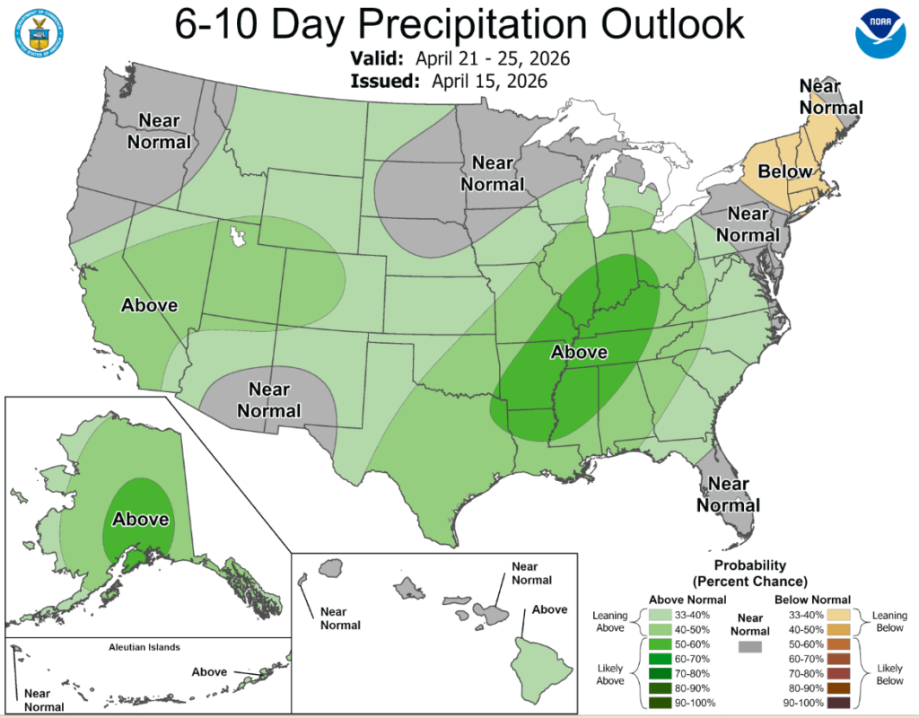
According to the 6-to-10-day precipitation outlook map, eastern Oklahoma is leaning above a 40-50% chance of precipitation through April 25th, while western Oklahoma is leaning above a 33-40% chance through that same date.
Much of the country continued to experience above-normal temperatures in April. During the last week, the warmest temperatures were over the southern Midwest and into the central Plains, where departures were 9°F or greater. California and portions of the Southeast into the Mid-Atlantic were near normal to slightly below normal. Dryness has continued in the Southeast, portions of the South, the Northeast, and much of the High Plains. The greatest precipitation occurred in the Great Basin, northern California, central and west Texas, northeast Kansas, and across much of Michigan and Wisconsin, where spring thunderstorms developed within an active weather pattern, mainly over the Midwest.
In the South: Precipitation was mixed across the region. Oklahoma and much of central and western Texas received more than 150% of normal precipitation. Farther east, eastern Arkansas and Louisiana saw light precipitation, while areas farther west and into Tennessee remained mostly dry. Temperatures were above normal across much of the region, with only southern Texas, southern Louisiana, and eastern Mississippi near or below normal. The greatest departures occurred in western Oklahoma and the Texas Panhandle, where temperatures were 12–15 degrees above normal. Drought expanded and intensified across much of Tennessee, with moderate and severe drought expanding statewide and a new area of extreme drought developing in the northwest. In Mississippi, moderate and severe drought expanded across eastern and southern areas, with extreme drought expanding in the northwest. Arkansas remained dry, with extreme and exceptional drought expanding in both northern and southern areas. Louisiana saw expansion of extreme drought across much of the south, as well as central and northern areas. Moderate and severe drought also expanded across southern portions of the state. Oklahoma remained largely unchanged, with only minor expansion of severe drought in the panhandle. The most significant improvements occurred in Texas, where much of central, southern, and southeastern portions of the state saw a full-category improvement in drought conditions. However, severe drought expanded in parts of the panhandle.
In the high Plains: Temperatures were mostly above normal, with only eastern North Dakota and northeast South Dakota near or below normal. The greatest departures occurred in central Kansas, where temperatures were 12–15 degrees above normal. Above-normal precipitation was observed in southwest and northern North Dakota. Kansas experienced the most active weather, with southwest and eastern areas of the state and southeast Nebraska recording above-normal precipitation. Some areas of northeast Kansas received more than 400% of normal precipitation. These rains led to improvements in abnormally dry and moderate drought conditions across southeast Nebraska and northeast Kansas. Some areas of eastern Nebraska and south-central Kansas also saw improvements. Extreme drought expanded across southwest Nebraska and northwest Kansas, while severe drought expanded across southwest Kansas. The plains of eastern Colorado experienced nearly a full-category degradation, with expansion of moderate, severe, and extreme drought.
In the West: Warmer-than-normal temperatures dominated the region this past week. Departures were 6–8 degrees above normal across most of Utah, Colorado, and Wyoming. Only the Sierra Nevada area and northern California were near to slightly below normal. Precipitation was mixed, with parts of northern California, northern Nevada, eastern Oregon, southern Utah, eastern and western New Mexico, southwest Idaho, and eastern Washington receiving above-normal precipitation. The lack of snowpack will continue to impact the region in the coming months. Earlier-than-normal snowmelt, below-normal seasonal totals, and increased liquid precipitation are contributing to hydrological impacts. Changes this week included improvements in moderate drought in northeastern California and expansion of moderate and severe drought in southern Arizona. Southern Idaho into northern Nevada saw expansion of severe, extreme, and exceptional drought, while severe drought expanded across eastern and northern New Mexico.
To view the 6-10 Day Precipitation Outlook Map, click here.
To view the 6-10 Day Temperature Outlook Map, click here.
To view the Monthly Drought Outlook Map, click here.


