

To view the latest Oklahoma drought map, CLICK HERE.
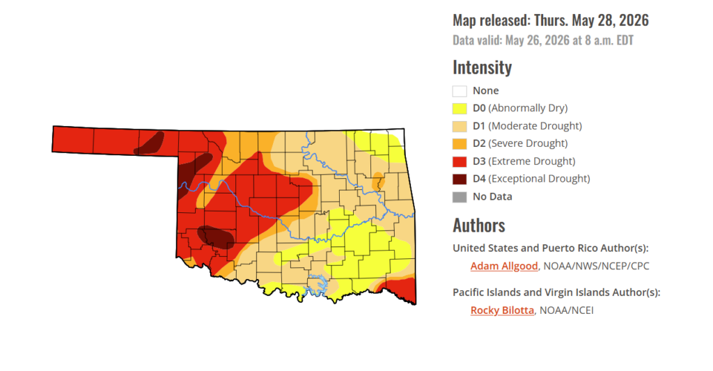
Drought conditions across Oklahoma remain sharply divided, with improving moisture in the east contrasting with worsening dryness in the west. While rainfall has eased conditions in some areas, western Oklahoma continues to face intensifying drought, stressing pastures, crops, and water supplies. The latest drought data shows I-35 still serving as a general dividing line between relief in eastern Oklahoma and worsening conditions farther west as producers move deeper into the summer season.
According to the latest Drought Monitor, exceptional drought persists in parts of western Oklahoma, including Kiowa County, Ellis County, Beaver County, Woodward County, and surrounding areas. Historic impacts of exceptional drought include rising hay and water costs, limited supplies, and herd liquidation by producers. Ranchers and farmers are facing severe economic losses as failed crops are baled or abandoned, pastures turn bare, and cracked, dry land leaves some fields unusable. Exceptional drought currently covers 4.35% of the state.
Moderate to extreme drought conditions in the current period indicate that 81.25% of the state is affected. At this point, only 0.65% of the state remains drought-free in far northeastern Oklahoma.
The trend of easing drought conditions in eastern Oklahoma and worsening conditions in western Oklahoma continues, with I-35 generally serving as the dividing line between the two.
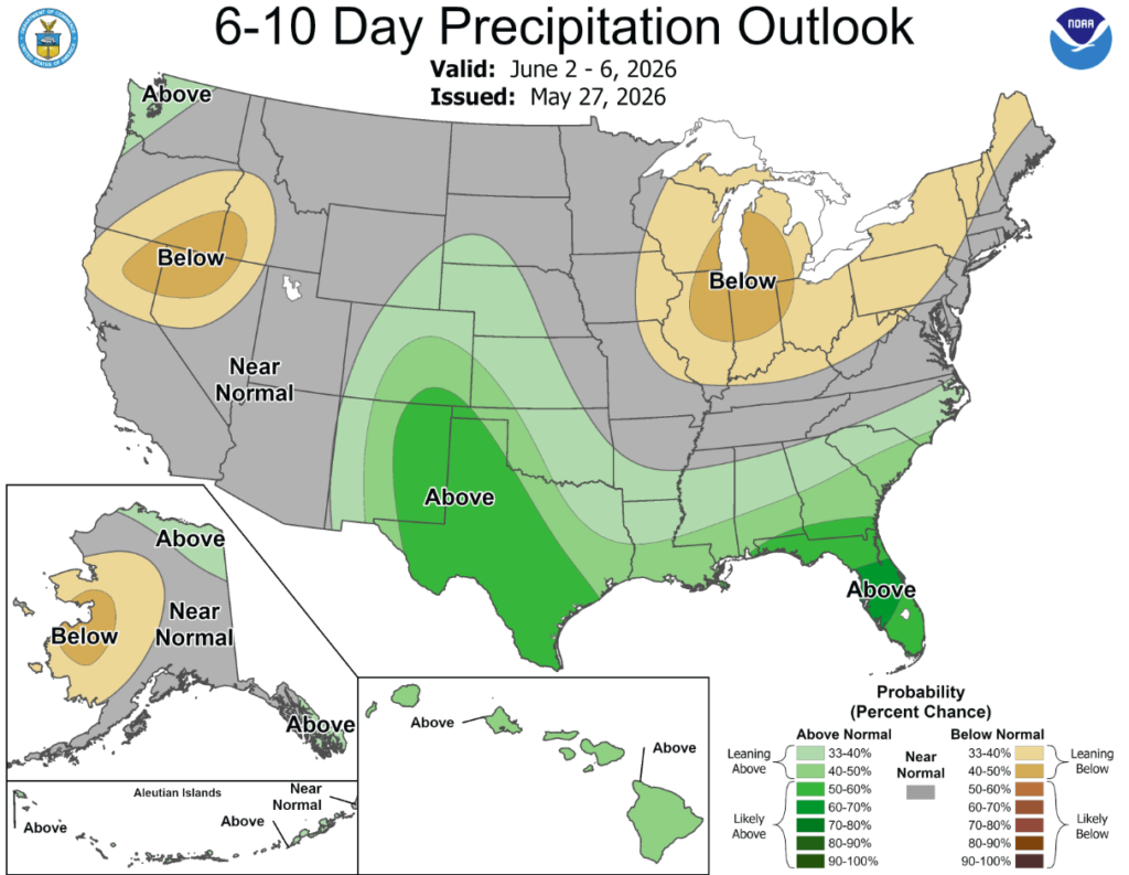
According to the 6-to-10-day precipitation outlook map, a majority of Oklahoma is leaning above a 33-50% chance of precipitation through June 6th, while northeastern Oklahoma is expecting near normal conditions through that same date.
During the week, a highly variable weather pattern brought wide temperature swings to much of the contiguous United States. An unusually cold airmass that had settled over the Plains at the start of the week pushed eastward, bringing a rapid and stormy end to the early season heat wave across the Eastern Seaboard. In contrast, the West baked under much above normal temperatures. By mid-week, much above-normal temperatures had returned to the Plains, with daily maximum temperatures climbing into the upper 90s in some locations. As temperatures began to rebound across the East, cooler air overspread the Pacific states by the end of the week. The strong temperature gradients that set up across the Nation, coupled with ample Gulf moisture streaming northward resulted in widespread heavy and persistent precipitation, with many locations exceeding two inches from eastern Texas and Oklahoma northeastward to the mid-Atlantic states, and isolated instances of 6 or more inches in some spots. Widespread rainfall, albeit with lighter accumulations, fell across the north-central Plains as daily temperatures warmed, but mostly dry weather prevailed across the upper Mississippi Valley and western Corn Belt. West of the Rockies, mostly dry weather prevailed for most of the week, but showers associated with a strong cold front overspread the Northwest at the very end of the period.
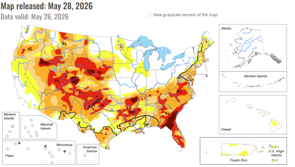
In the South: Widespread heavy rainfall overspread the Southern Region, with amounts increasing from west to east. Accumulations of 2 to locally more than 5 inches fell across most of Tennessee, engendering widespread drought reduction. Rainfall was locally heavy but a bit spottier across Louisiana and Arkansas, which also saw widespread drought reduction but with less coverage. Across Texas, heavy rainfall across the eastern half of the state yielded drought improvements and also localized flooding. Across North Texas, localized convection brought relief to some areas, but hot conditions resulted in degradation where precipitation did not occur.
In the High Plains: As below-normal temperatures transitioned back to a hot pattern across the High Plains, widespread precipitation moved through the region. Areas of convection brought up to 2 inches of rain to portions of eastern Nebraska and eastern Colorado, while amounts were generally an inch or less elsewhere. This precipitation was sufficient to bring some drought reduction across northern and northeastern Colorado, but drier conditions across southeastern Colorado and Kansas, coupled with hot temperatures, resulted in degradation. A sharp cutoff in precipitation was also noted across the far western Dakotas, where small areas of degradation were noted along the borders with Wyoming and Montana.
In the West: Mostly dry weather and above-normal temperatures dominated the Western Region during the week sparking some small-scale degradation across Montana, Idaho, and New Mexico, where the effects of the meager winter snow cover are beginning to be felt in falling streamflow values. Status quo was maintained west of the Rockies for the most part, as reservoir conditions remain good across California during a climatologically dry time of year. At the end of the week, a strong cold front brought abnormal moisture to the Northwest and northern Rockies. While not sufficient to substantively alter the drought depiction, a modest reduction in abnormal dryness was noted in far northwestern Washington.
To view the 6-10 Day Precipitation Outlook Map, click here.
To view the 6-10 Day Temperature Outlook Map, click here.
To view the Monthly Drought Outlook Map, click here.