
State Climatologist Gary McManus recently sat down with Farm Director KC Sheperd to address the rapidly deteriorating weather conditions across Oklahoma. Over a brief period, severe heat and lack of rainfall have triggered a significant flash drought, drastically altering soil conditions, agricultural outlooks, and surface water supplies statewide.
The Rapid Rise of Oklahoma’s Flash Drought
The speed at which Oklahoma transitioned into widespread drought conditions has caught many off guard. July ranked as the 30th driest and 20th hottest on record, setting the stage for an even harsher August. The first two weeks of August have continued this trajectory, putting the month on track to be among the top ten driest and hottest Augusts on record if significant precipitation does not arrive soon.
This extreme heat paired with minimal rainfall has resulted in a classic flash drought scenario—a rapid intensification of drought conditions that leaves little time for preparation.
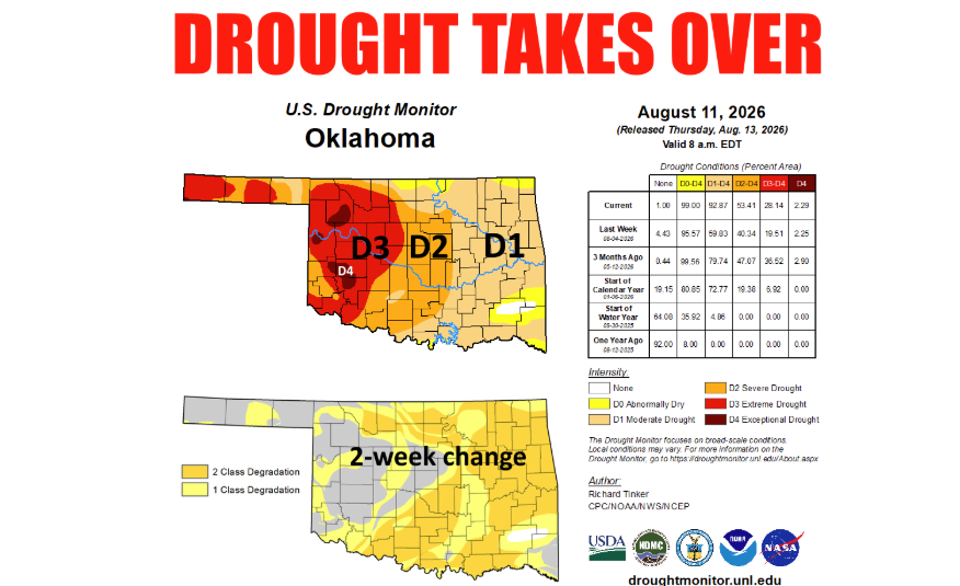
- Drought Expansion: Over just a couple of weeks, drought coverage across Oklahoma jumped from 44% to 93%.
- Severe Severity: Over 50% of the state is currently experiencing at least severe drought.
- Extreme Conditions: More than 25% of Oklahoma is categorized in extreme or exceptional drought, the two most critical levels on the U.S. Drought Monitor.
Similar patterns occurred during the summers of 2022 and 2023, but conditions are escalating with exceptional speed.
Drought Monitor Delays vs. Real-World Impacts
A common frustration among agricultural producers—particularly in Western Oklahoma—is that official drought maps can lag behind real-world conditions. McManus explained that the U.S. Drought Monitor is not solely an impact scale, but rather a “convergence of evidence.” It integrates multiple indices, including vegetative health, soil moisture levels, and precipitation deficits.
Because the Drought Monitor enforces fail-safe rules limiting how rapidly a region can drop in category per week, the official map often lags behind localized agricultural realities during a flash drought. Climatologists rely heavily on direct impact reports from local producers to convey accurate recommendations to national drought authors.
Depleting Surface Water and Regional Hotspots
Surface water supplies across Oklahoma are deteriorating rapidly:
- Farm Ponds & Stock Tanks: Many local stock tanks have dried up entirely. The remaining water in several ponds has become too brackish for livestock consumption.
- Producer Workarounds: Farmers and ranchers across the western half of the state have been forced to haul water and feed supplemental hay to sustain livestock.
- Reservoirs: Major reservoirs in Western Oklahoma are beginning to dwindle, while the surplus water stored in Eastern Oklahoma during late spring has largely evaporated or returned to below-normal levels.
Hardest Hit Regions
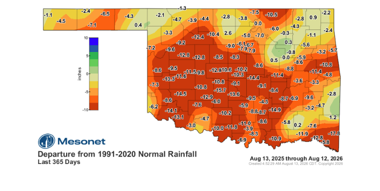
The most critical moisture deficits span a cone-shaped area stretching from Far Western Oklahoma into Central Oklahoma, alongside the Panhandle.
In West Central Oklahoma, the last 365 days have ranked as the driest or second-driest period on record, with localized rainfall deficits reaching 10 to 12 inches. While early summer brought brief relief, conditions have rapidly reversed, pushing the state back toward near 100% drought coverage.

Short-Term Outlook: Wildfire Risks and Dry Storms
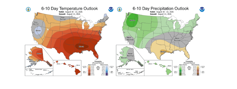
The immediate forecast offers little respite for agricultural operations. High temperatures and dry conditions are expected to persist through the remainder of August.
- Vegetation Loss: Pastures and crops are going dormant or dying, severely depleting soil moisture.
- Wildfire Danger: Fire risks continue to climb due to dormant vegetation and dry winds.
- Dry Thunderstorms: Areas in the Panhandle and Far Northwest Oklahoma face potential “dry thunderstorms,” which bring dangerous lightning and high winds without meaningful rainfall, increasing the risk of spot fires.
Long-Term Outlook: Hope on the Horizon with El Niño
Despite the challenging short-term weather pattern, climatological models point toward potential relief later in the year.
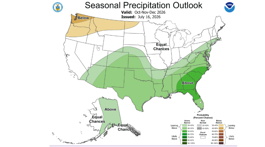
A strong El Niño event is building and is projected to be among the strongest on record. Historically, a strong El Niño increases the statistical odds of above-normal precipitation across the Southern Plains through late autumn, winter, and early spring (October through April).
While an autumn weather pattern shift is not guaranteed, the strengthening El Niño provides a promising outlook for alleviating Oklahoma’s severe moisture deficits as the region transitions into the cooler months.